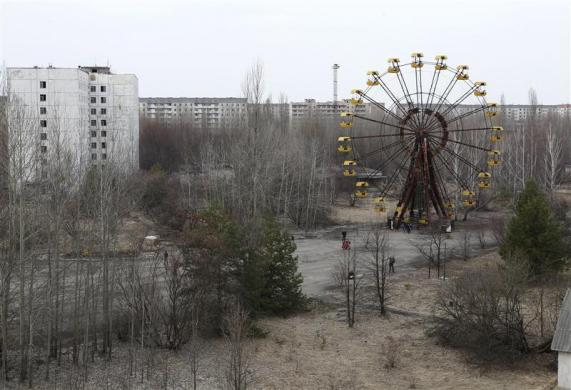
....seems fitting that Chernobyl has become iconic of man's follies and post-apocalyptic decline......There's something about amusement parks...

(Pripyat amusement park, Chernobyl.)
This message board permanently closed on June 30th, 2020 at 4PM EDT and is no longer accepting new members.
....seems fitting that Chernobyl has become iconic of man's follies and post-apocalyptic decline......There's something about amusement parks...
(Pripyat amusement park, Chernobyl.)
....HA!.....the group I'm aware of has seen orbs there, vehicles have stopped running for no apparent reason and the feeling of the place is "bad"....I will go one of these days on my own-see what happens.....

....seems fitting that Chernobyl has become iconic of man's follies and post-apocalyptic decline......
Yes, those are exactly the ones I remember! Fun times, indeed!!!! ♥
 but really fun times.


 ...
...

...you are one pretty lady, which is set off even more by the macabre background....Oakhill Cemetery is our oldest cemetery here in my hometown it covers more than a 100 acres and it changes constantly in its appearance, iron gates, trees, rolling hills, winding dirt roads through woods, beautiful stuff. Legend has it that the outlaw Doc Holliday is buried there in an unmarked grave beside his father. Long ago and once upon a time I took Stephen's Gingerbread Girl story there, I thought it would be cool if it had 'been to a graveyard too', before it completed its worldly journey and final destination as it became a gift to Stephen from the SKMB.
It was my most fun time at a cemetery but in a rushed hurry on lunch hour, had to keep it moving! Warning: the only thing creepy in these photos, was ME!
It was this photo of Stephen that made me want to do what I did do, when I got it there.
View attachment 22113
this was my Headstone Headshot with a 1408 hat ...with the 'Gingerbread Girl'
it was different than I thought! ....
going crazy with the Gingerbread Girl!
and then
and reading and chilling at Oakhill ...
 This cemetery sets along side Interstate 29 several miles North out of St. Joe Missouri in Atchison County Missouri, I first came across it riding my HD on a road trip to Omaha NE. I needed to stop to take a restroom break, the off ramp emptied out at a run down closed up gas station, which I ducked in behind to do my business, while I was stretching my legs I noticed this cemetery sitting off in the distance and strung up the side of the hill. I decided to walk up there and take a closer look. This is the only cemetery I've ever seen which has 1. no road...no pathways...no trails running through it or around it or in it 2. the head stones are not in straight lines, there is no order at all to the lay out of this cemetery.3. It may not look steep but it is steep 4. the mausoleum pictured has two double doors with little diamond cutouts in each one the cutouts in total are probably the size of my face, I know because I was bold enough to look into them, when I looked down at the bottom of the metal doors the ground had been dug away like an animal had been in and out of there and that my friends is as far as I made it up the hill because by then I was hearing sounds, and possibly some dueling banjos and it was back down the hill as fast as my boots would take me and hoping like hell by old bike would start up and get me the H*LL outta there!! But it was exciting let me tell you, and I've never forgot this place! I had to look awhile to find a picture to share it with you, also on the day I first saw this cemetery the grass had been recently burned off, and many of the stones were black with soot, which I thought was also strange as I've never known a cemetery to be burned off before.
I'd like to know the name of the cemetery, was there a marker or plaque to tell you?View attachment 22138 This cemetery sets along side Interstate 29 several miles North out of St. Joe Missouri in Atchison County Missouri, I first came across it riding my HD on a road trip to Omaha NE. I needed to stop to take a restroom break, the off ramp emptied out at a run down closed up gas station, which I ducked in behind to do my business, while I was stretching my legs I noticed this cemetery sitting off in the distance and strung up the side of the hill. I decided to walk up there and take a closer look. This is the only cemetery I've ever seen which has 1. no road...no pathways...no trails running through it or around it or in it 2. the head stones are not in straight lines, there is no order at all to the lay out of this cemetery.3. It may not look steep but it is steep 4. the mausoleum pictured has two double doors with little diamond cutouts in each one the cutouts in total are probably the size of my face, I know because I was bold enough to look into them, when I looked down at the bottom of the metal doors the ground had been dug away like an animal had been in and out of there and that my friends is as far as I made it up the hill because by then I was hearing sounds, and possibly some dueling banjos and it was back down the hill as fast as my boots would take me and hoping like hell by old bike would start up and get me the H*LL outta there!! But it was exciting let me tell you, and I've never forgot this place! I had to look awhile to find a picture to share it with you, also on the day I first saw this cemetery the grass had been recently burned off, and many of the stones were black with soot, which I thought was also strange as I've never known a cemetery to be burned off before.
It called Mt. Hope Cemetery in Atchison County Missouri, I didn't see a marker for it at the time though I had to go back on google and find itI'd like to know the name of the cemetery, was there a marker or plaque to tell you?
...you are one pretty lady, which is set off even more by the macabre background....

View attachment 22138 This cemetery sets along side Interstate 29 several miles North out of St. Joe Missouri in Atchison County Missouri, I first came across it riding my HD on a road trip to Omaha NE. I needed to stop to take a restroom break, the off ramp emptied out at a run down closed up gas station, which I ducked in behind to do my business, while I was stretching my legs I noticed this cemetery sitting off in the distance and strung up the side of the hill. I decided to walk up there and take a closer look. This is the only cemetery I've ever seen which has 1. no road...no pathways...no trails running through it or around it or in it 2. the head stones are not in straight lines, there is no order at all to the lay out of this cemetery.3. It may not look steep but it is steep 4. the mausoleum pictured has two double doors with little diamond cutouts in each one the cutouts in total are probably the size of my face, I know because I was bold enough to look into them, when I looked down at the bottom of the metal doors the ground had been dug away like an animal had been in and out of there and that my friends is as far as I made it up the hill because by then I was hearing sounds, and possibly some dueling banjos and it was back down the hill as fast as my boots would take me and hoping like hell by old bike would start up and get me the H*LL outta there!! But it was exciting let me tell you, and I've never forgot this place! I had to look awhile to find a picture to share it with you, also on the day I first saw this cemetery the grass had been recently burned off, and many of the stones were black with soot, which I thought was also strange as I've never known a cemetery to be burned off before.


 Lyle Van Houten's Automotive Museum – Clarence, Missouri- Atlas Obscura
Wow, great find with this picture it really shows everything better than the one I had found! When I saw this cemetery the grass had recently been burnt off and it was black as pitch, I had soot all over the bottoms of my boots...I can't imagine how creepy it would've been seeing the place on fire!! I liked the article on the old gas station, it was also pretty creepy!!Your encounter is Fascinating!!! I cant imagine the terror when you heard those banjos! You are a biker? I found a couple of more shots of it as the cemetery is location is listed at the Find A Grave website, they actually have 9 photo requests for stones of people buried in that cemetery on '317 Street' . I tried to zoom in on It at Google earth hoping to glimpse the gas station, but it was limited zoom. Strange how everyone is buried on such a steep massive hill!
this is a sign that is there ....
heres what the sign says more clearly ...
heres another angle of it further away ....
and one more ....
Oddly while researching this place I found another cemetery just 3 hours from it, also off of an I29 exit, an abandoned filling station on the edge of a graveyard, ironically! Its here ......
Wow, great find with this picture it really shows everything better than the one I had found! When I saw this cemetery the grass had recently been burnt off and it was black as pitch, I had soot all over the bottoms of my boots...I can't imagine how creepy it would've been seeing the place on fire!! I liked the article on the old gas station, it was also pretty creepy!!

Stull Cemetery sounds really cool, I live in Kansas and did not know about this place....I will check it out some day! I have always thought I'd like to stop back by the Loess Hill cemetery but I'm never going that way for any reason...if I happen to I will stop and take pictures!! I had the very same thoughts about the soil there, it has to be hard digging, and full of rocks I would think, add that with the steepness of the grade and it took some real dedication to bury so many people in that spot...just across the interstate on the West side the land is flat as a pancake and they plant corn there...that would have made more sense...but not as good of a story for sure. There is another cemetery I know of and have visited a couple of times which sits on top of a hill North of the town of Harlan Kansas in a pasture, I put a probe down and hit rock at 3 inches deep...solid limestone, I found a bone laying outside of one of the graves and took it to a local fossil expert/bone man, he said it wasn't human but was a horse bone, he said he'd also been to that cemetery and said there were no human bones left there anymore...anyway, there are two stones in that cemetery which have foreign writing and some strange markings I'll have to go back up there sometime and take some pictures of that one to share.Another thing that I was looking at , on that marker, was when it said it was a 'Loess Hill' and what that means, and theyre hills formed by this strange kind of wind blown soil deposits, less than 20% clay! and its very hard when dry, but soften and incohesive when its wet! Why would people bury people in it ? its not the only one , there was another one 2 hours from it in Iowa!
I was thinking, what if they burnt the ground to harden the soil, but that would be insane, clearly in the photos, those stones are just scattered in such a chaotic manner all over the place. You really should drop back by there some time, and get some pictures, and another creepy story to tell, I think there something going on there!
When you mention the burnt ground you saw, it makes me think of another graveyard in years past that investigators would have to go thru hell and high waters to get into, it was so restricted, and said dangerous, because it was said to be burning from beneath the ground and that the ground would often smoke, it was called the Gateway to Hell... I found a link with its creepy history and back story ....
Haunted Stull Cemetery is America's Most Off-Limits Portal to Hell
Waverly Hills Sanatorium Louisville, KY...most demonic place i have ever ghost hunted in. Also, the ever famous Stanley Hotel, Estes Park, CO....Got to sleep on 4th floor (most haunted) and ghost hunt for 5 days. So many happenings and stories...I don't have enough room to list.
Also, tons and tons of old ghost towns and abandoned mines, cemeteries up here in the Upper Peninsula, MI. On a hike my son and I stumbled upon an OLD cemetery in the forest from 1800s. Really amazing what you will find up here. Things are frozen in time in so many places of the Upper Peninsula! We love exploring!
I would like you to check in so we know you are okay.Since age 9 I have been an incurable cemetery hag. To kick off this topic, here are pictures from my 2012 California trip at the graves of Ray Bradbury, Buster Keaton, and Stan Laurel.


I've heard of Waverly Hills, and I've heard it's absolutely nuts and not for the faint of heart!
Not haunted maybe, but creepy I'm sure--anyone tried or know of anyone who's tried to cross the Darien Gap? Sounds like the Derry Barrens on steroids.
The Darién Gap is subject to the presence and activities of the Marxist Revolutionary Armed Forces of Colombia (FARC), which has committed assassinations, kidnappings, and human rights violations during its decades-long insurgency against the Colombian government.[22] FARC rebels are present on both the Colombian and Panamanian sides of the border.[23] In 2000, two British travelers, Tom Hart Dyke and Paul Winder, were kidnapped by suspected FARC guerillas in the Darién Gap while hunting for rare orchids, a plant for which Dyke has a particular passion. The two were held captive for nine months and threatened with death before eventually being released unharmed and without a ransom being paid. Dyke and Winder later documented their experience in the book The Cloud Garden and an episode of Locked Up Abroad.
Other political victims of the Darién Gap include three New Tribes missionaries, who disappeared from Pucuro on the Panamanian side in 1993.[24]
In 2003, Robert Young Pelton, on assignment for National Geographic Adventure magazine, and two traveling companions, Mark Wedeven and Megan Smaker, were detained for one week by the United Self-Defense Forces of Colombia, a pro-government paramilitary organization, in a highly publicized incident.[25][26]
From May 2013, Colombian neo-paramilitary forces were reported to be very active in the Darién around Los Katios National Park and the Cuenca Cacarica [27] In 2013, Swedish backpacker Jan Philip Braunisch disappeared in the area after leaving the Colombian town of Riosucio with the intention of attempting a crossing on foot to Panama, via the Cuenca Cacarica. His skeletal remains were recovered in June 2015 with evidence he had been killed with a shot in the head. The FARC admitted to killing him, confusing him for a foreign spy.[28]